 |
The NSB Assembly recently approved a $3,830,150 program to create and use geographic information on the North Slope. The program is known as the NSB Geographic Information System of “GIS.” Under this system a vast quantity of new data on natural resource and other map related features will be collected, automated and stored in a data base for use by the Borough as well as other organizations doing work on the North Slope. In addition, several state and federal agencies have expressed interest in utilizing the GIS and are expected to contribute funds.
 |
Mapping Provides a Political Forum
Mapping plays a key role in the development of Alaska. The political conflicts that engaged Congress preceding the passage of the Alaska National Interest Lands Conservation Act (ANILCA) had mainly to do with the setting of the boundaries of various types of jurisdictions, each under different regulatory control. The traditional culture of the North Slope Inupiat and modern North Slope residents also realize the relationship between geography and survival. Knowing where and when migratory food resources are available is a matter of precise geographic information. Being able to protect those same areas will guarantee the survival of future generations.
Many of the genuine resource conflicts in Alaska have resulted from the lack of precise geographical information addressing such questions as, “Where do the caribou feed?”, “Where do the seals den?”, “Where is it safe to drill?” All parties realized the crucial role of maps and map-making in resolving these conflicts. With the aid of accurate maps, planning can often resolve resource conflicts before they arise.
Enter the Computerized Map
The enormous geography of Alaska would make the detailed maps needed for planning cumbersome and impractical without the help of computers. With a computer mapping program, a single map can be overlaid hundreds of times to illustrate differing characteristics of the same, once-drawn, area. The juxtaposition of these overlays often reveal surprising geographic characteristics.
The NSB decided to undertake the sophisticated challenge of computerized geoprocessing as a result of the late Mayor Eben Hopson’s service on the Alaska Coastal Policy Council and the influence of two pioneer geoprocessing enthusiasts, Anchorage Municipal Assemblywoman Lydia Selkregg — who served on the Council with Hopson — and Jim Anderson, now director of the Department of Natural Resources’ Division of Technical Services.
ARIS: Alaska’s Computer Mapping Attempt
As a first step, the Borough contracted, in 1978, with Faye Alexiev of Research Design Productions in Anchorage to introduce the technology of computer mapping in land use management to Borough departments. Her initial work included a demonstration project which automated all data attendant to the Beaufort Sea Coastal Zone Management Plan.
At that time, a statewide geographic information system had been initiated by the Joint Federal-State Land Use Planning Commission. Known as the Alaska Resource Information System (ARIS), it was envisioned as the beginning of a common data base for Alaska, to be used by all federal, state, and local government agencies. System maintenance and information and update was the contractual responsibility of Esca-Tech Corporation, a subsidiary of Calista, an Alaska Native regional corporation. Esca-Tech was the only Alaskan computer operation having such mapping facility at that time.
The principle flaw in ARIS was found not in the technology, but in the reluctance of various government agencies to cooperate in the project. Each agency, with its unique set of goals and objectives, opted for the development of separate systems. A common data base was perceived by agency managers less than optimal to achieve the objectives of their own agencies.
Learning from this experience, NSB officials recognized the difficulties in “managing the managers” and set about to improve the quality of communications and understanding of Alaska’s land management issues in order to implement a geographical management system.
The Computer Graphics Conferences
In response to this problem, Alexiev in 1980 organized the First Alaska Conference on Computer Graphics and Geoprocessing recruiting for the occasion the most prominent authorities in the field of computer graphics applications — most of them on the faculty of Harvard University. Sponsored by the NSB, this event created a new forum for decision makers, managers, and technicians to discuss and create a common framework for communication and data compatibility.
The Borough’s GIS
That same year, the state granted federal Coastal Zone Management funds to the NSB to study the feasibility of the Borough developing its own automated municipal map. NSB officials selected Jack Dangermond, President of Environmental Systems Research Institute of Redlands, California, to head up the project. Under the auspices of the Alaska Coastal Management Program and the Office of Coastal Management of the National Oceanographic and Atmospheric Administration (NOAA), Dangermond conducted a major investigation of GIS applications in the North Slope.
Geographic information systems were also being planned by other government agencies in Alaska. The State Department of Natural Resources, the Army Corps of Engineers, and the U.S. Fish and Wildlife service are among those currently completing their own computer mapping projects. These recent developments have highlighted the need for effective computer networking between a wide range of systems and users.
In August, 1981, the first conceptual design and implementation plan for a GIS on the North Slope was made available. Concurrently, intensive mapping and other data development were undertaken for a small pilot area in the Kuparuk region between the Colville Delta and Milne Point. This initial demonstration of GIS capability for the North Slope was completed in January 1982.
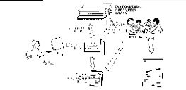
System Description
As now envisioned, the GIS will consist of four basic parts:
a. Environmental Information System
b. Automated Review and Comment System (ARCSystem)
c. Library and Information Services System, and
d. Land Records System.
Each of these four modules contains two basic parts: a data base and a processing capability for storage, retrieval, and analysis of this data. The following is a short description of each of these modules.
Environmental Information System
The purpose of the Environmental Information System is to develop and maintain very accurate and specific environmental data concerning the Borough’s 88,000+ square miles of land and offshore area. This is the first and most important component of the GIS program.
This system will provide a series of maps, at several scales of resolution (1:250,000; 1:63,360; and 1:12,000). These maps will chart the exact positions of land form, geology, vegetation, waterways, and land use. Upon these same maps will be charted the major wildlife habitats, fish spawning grounds, over wintering sites, and a variety of other parameters. For Barrow and the villages, very detailed maps of building sites, pipelines, roads, and related infrastructures will be prepared.
To make these maps as useful as possible, they will reside on an independent computer under the direct control of NSB personnel. The Environmental Information System will be the main repository and access tool for all mapped environmental information on the North Slope. The data base on this module will be accessible to the other modules and also to other agencies and private online users.
The Automated Review and Comment System (ARCSystem)
The purpose of the ARCSystem is to automate the Borough’s response capability in the permit review process in which federal and state agencies request Borough comments concerning development and environmental issues. The task is complicated, not only by the increasing number of such requests, but also by the fact they often require redundant and repetitive geographic and policy research. The ARCSystem will link together Borough legislation, regulations, and policy decisions with the resource data base and automated mapping system and will be able to automatically compose letters of response which are very thorough and very nearly complete, requiring only staff review and editing before release.
The ultimate goal of the ARCSystem is the capability to respond quickly and comprehensively to all requests for comments from any agency. by its ability to link Borough policy with automated mapping, the system will have the capability to generate highly informed and well documented responses to any environmental issue.
 |
The Automatic Review and Comment System (ARCSystem) is essentially a word processor that makes use of the NSB data stored in the Environmental Information System (EIS) to aid NSB staff respond to requests for review and comments on proposed industry projects. the ARCSystem researches the EIS for pertinent data, organizes it into a response, and prints out a report for the staff to review. |
Library and Information Services System
The purpose of the Library and Information Services System is to provide users with easy computerized access to Borough documents and all bibliographic references that relate to environmental issues on the North Slope.
This module will consist of two parts. The first is a standard computer time-sharing system with a data base composed of a catalog of such environmental references. Each entry will refer to a published book or article about some North Slope environmental topic or to a NSB document. It will contain a short abstract of the work, along with several key descriptor words. By typing in a request for certain types of information, users will be provided with those bibliographic references and abstracts in which the descriptor words match the information requested. The user will also be informed as to where and how one can obtain a copy of the original publication. This bibliographic data base will be accessible to both researchers and the general public with telecommunications capability.
The second part of the Library and Information Services System will be an actual library in the new Borough office building in which the majority of Borough-owned books, journals, reports, maps, oral histories, and the like will be available to the public on a check-out basis.
The Library and Information Services System will be a one-stop shopping center for all types of information concerning the North Slope and the Borough. The complete historical and scientific records of the Borough will be preserved for reference today and for future generations.
The Lands Records System
The purpose of the Lands Record system will be to automate the drafting and recording of all land records in a separate computer-based system. Currently, land records for the North Slope exist piecemeal in a variety of State, Federal, and NSB offices. The Lands Records System will combine the data in all these files under one roof, and will make this data available via an interactive computer system. Like the other three modules of the GIS, the data stored in the Lands Records System will be accessible from remote terminals throughout the Borough.
Land ownership, mineral rights and other legal records concerning the control of land are an extremely important type of information. The exactitude of measurement and the detail of valuation assessment set land records apart from other types of environmental data. For these reasons, the Land Records System will exist separately from the other modules. At the same time, the Lands Records System will be able to interact with other modules so that the data it accumulates can be used in the analyses of the Environmental Information System or the various processes of the ARCSystem.
Costs and Benefits
The GIS should be up and operating, according to NSB officials, by 1984, complete with digitized maps and geographic information. Annual operating costs are expected by be $152,000.
Even though placing the benefits of the system in a dollar figure is not always possible, they will be tremendous. Saving one bowhead whale is worth $500,000 to the residents of the North Slope. Saving 100 caribou is worth $100,000 a year. These savings alone would justify implementation of the system.
Another example of the dramatic consequences of implementation of the GIS would be the measurements and evaluations of the long-term impacts of oil spills and other forms of pollution which could result from pipeline breaks and other predictable accidents.
Another way to look at benefits is in the context of present operating costs and efficiency of the North Slope borough Administration. At present, Borough staff is extremely pressed to respond to requests for comments from State and Federal agencies. Less than 25 percent of these requests are answered by the Borough. Those requests that are answered often contain incomplete information. This leaves organizations responsible for the development and environmental protection of the North Slope with little feedback from the Borough staff. The Review and Comment System will greatly expand the capability of Borough staff to research and comment upon these requests. Much of the work will be entirely automated.
Present and future generations will seek to understand this land. Using the publicly accessible data of the GIS, they will have a record which documents both distribution of the abundance of wildlife as it was in the past, is now, and will be in the future. The environmental impacts of industrial accidents will be identified and a priceless environmental tool will be handed down.
Finally, the creation of the Geographic Information System will encourage intelligent design of human activity in the Alaskan Arctic. By creating a detailed record of the natural condition of the Slope and integrating this knowledge with the planning process, effective protection of the environment will be a step closer.
 |
 |
| This photo interpreter is using a stereoscope and two adjacent aerial photos to obtain a three-dimensional view of the area being mapped. The photo interpreter then drafts stream lines, vegetation types, and other spatial data onto the map. | Mapping lines are input to the computer using a digitizing machine. The operator is manually tracing the mapped lines using a hand-held cursor to transmit the line location through the electrically-sensitive digitizing board (underneath the map) to the computer which records the location in numeric code. |